In order to calculate the SAA, it is help to start by calculating the zenith angle which is the angle between the Sun and the point directly overhead at solar noon. To determine the zenith angle, subtract the solar declination from the location latitude. If either the declination or location is in the Southern Hemisphere, assign it a negative value. Always report the absolute value of the calculated zenith angle (no negative zenith angles).
Zenith angle = (Location latitude) – (Solar declination)
Lastly, in order to calculate the SAA, simple subtract the zenith angle from 90°. Remember that the SAA is an angle, so do not label the SAA with North or South.
Example:
Las Vegas, Nevada (36°N) on December 21 (23.5°S solar declination)
Zenith angle = 36° - (-23.5°)
Zenith angle = 36° + 23.5°
Zenith angle = 59.5°
SAA = 90° - 59.5°
SAA = 30.5°
Q13. Calculate the zenith angles and solar altitude angles for the following locations at the specified dates. Recall the dates of the solstices and equinoxes in order to determine the solar declination for each of the dates listed. Replace the question marks with the related answers.
Answers
a) Honolulu, Hawaii (21.3°N) on June 21st (23.5°N solar declination)
Zenith angle = 21.3° - 23.5° = -2.2° (absolute value is 2.2°)
Solar altitude angle = 90° - 2.2° = 87.8°
b) Rio de Janeiro, Brazil (22.9°S) on December 21st (23.5°S solar declination)
Zenith angle = -22.9° - (-23.5°) = 0.6°
Solar altitude angle = 90° - 0.6° = 89.4°
c) Cairo, Egypt (30.0°N) on March 21st (0° solar declination)
Zenith angle = 30.0° - 0° = 30.0°
Solar altitude angle = 90° - 30.0° = 60.0°
d) Sydney, Australia (33.9°S) on September 23rd (0° solar declination)
Zenith angle = -33.9° - 0° = 33.9°
Solar altitude angle = 90° - 33.9° = 56.1°
Related Questions
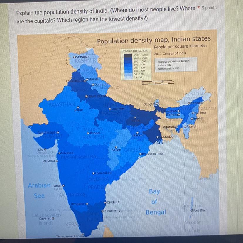
Explain the population density of India. (Where do most people live? Where are the capitals? Which region has the lowest density?)
Answers
Answer:
While the National Capital Region area of Delhi possesses the highest of the population density 2011 among the states of India having a statistics of 11,297 per square kilometre, the state of Arunachal Pradesh has the lowest record of population density having just 17 per square kilometre.
Explanation:
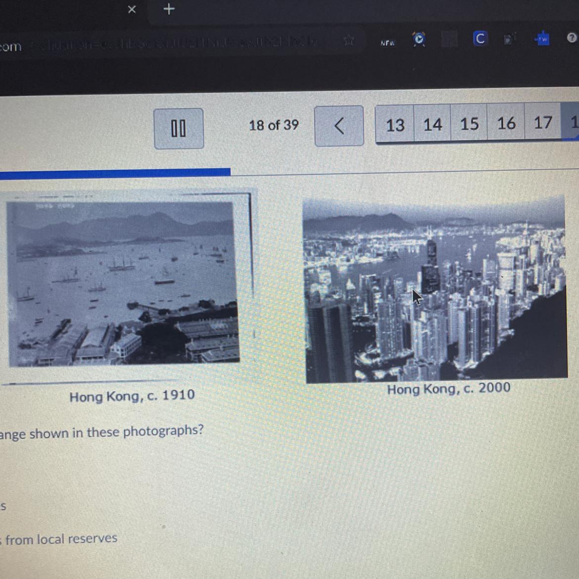
Which of the following most likely caused the change shown in these photographs
Answers
Answer:
i cant see the options for the answer
Explanation:
I dont know what caused them bc the options aren't shown
Answer:
larger populations? i can't see the answers g
Explanation:
Describe the rock layers shown in Diagram A and any forces acting on the rock.
Answers
Explanation:
HOPE IT HELPS
THANK YOU

the hockey team played 82 regular season games last year. if they won 44 games, what is the ratio of wins to losses
Answers
Answer:
22:19
Explanation:
Given parameters:
Number of games = 82
Number of wins = 44 games
Unknown:
The ratio of wins to losses = ?
Solution:
The ratio of wins to losses;
Number of wins : Number of losses
Number of losses = Number of games - Number of wins = 82 - 44 = 38
The ratio is;
44 : 38
or
22:19
concept of geomorphology
Answers
Answer:
Geomorphology is the study of landforms, their processes, form and sediments at the surface of the Earth (and sometimes on other planets). Study includes looking at landscapes to work out how the earth surface processes, such as air, water and ice, can mould the landscape.
Explanation:
:)
City A is located at 30° north latitude, while City B is located at 30° south latitude. Which city is closest to the
equator?
A City A
B City B
C Both cities are equally close
D City A in winter, City B in summer.
NEED ANSWER ASAP PLSSS
Answers
Let me know if this helped by hitting thanks or brainliest! If you have a question, please comment and I’ll get back to you ASAP.
Find the volume of the prism
A. 240ft
B. 343ft
C. 251ft
D. 232ft

Answers
Answer: B
Explanation:
The area of this prism is base x height , which is 49 * something. The volume must be divisible by 49, so the answer is B
Answer:
B
Explanation:
Just multiply 7 by 7 by 7 or 7 to the 3rd power and you get 343
Most of Arizona has an arid or semiarid climate. Georgia has a humid subtropical climate. Based on this information, which describes how Georgia’s climate differs from Arizona’s?
Answers
Answer:
Georgia receives more rain than Arizona.
Answer:
D:Georgia receives more rain than Arizona.
Explanation:
1. Why does the northern part of the Northern European Plain contain many swamps and lakes?

Answers
Answer:
its numerous lakes and swamps caused by the disarranged and immature drainage pattern, together with its thin soils and coniferous forests, the Finnish plain is similar in character and appearance to northern and eastern Canada, another heavily glaciated Precambrian Shield area.
Explanation:
7. What pair of countries contributes the most greenhouse emissions into the atmosphere?
A) England and Ireland
B) Germany and France
C) United States and China
D) Japan and South Korea
E) Russia and India
Answers
Answer:
C.
Explanation:
the average of two number is 55 to subtract from the greater number ratio between number become 1:2 the smaller number is
Answers
Complete question:
The average of two number is 55. If 2 is subtracted from the greater number, the ratio between the numbers become 1:2 . The smaller number is
Answer:
The smaller number is 36
Explanation:
let the smaller number = x
let the greater number = y
\(\frac{x + y}{2} = 55\\\\\)
x + y = 110
y = 110 - x --------- equation (i)
\(\frac{x}{y-2} = \frac{1}{2}\\\\ y-2 = 2x\\\\y = 2x + 2 ------equation(ii)\)
Substitute y in equation (ii)
110 - x = 2x + 2
110 - 2 = 2x + x
108 = 3x
x = 108 / 3
x = 36
Therefore, the smaller number is 36
Suspended load includes material
A. rolling along on the bottom of the stream
B. temporarily or permanently suspended in the flow
C. deposited on the bottom of the stream
D. rolling along the bottom and suspended in the flow
Answers
Answer: B. temporarily or permanently suspended in the flow
Explanation:
Suspended load refers to the sediments in a flowing waterbody that do not settle to the bottom but rather continually move with the motion of the water. They are therefore temporarily or permanently suspended in the flow.
They are usually made up of light and fine particles which can easily be moved such as silt and fine sands.
How does arithmetic density affect people who live in an area?
Answers
Answer:
In general, increases in population density equate to problems for a country. Urban areas with a high arithmetic density have an increased need for food, infrastructure, and health/human services.
Explanation:
a book
difference between choropleth and cartogram
Answers
Explanation:
Choropleth maps show us how much geographic area is affected. On some maps, this means that large regions where only a few people take up a lot of space on the screen. Population cartograms, on the other hand, drive more attention to populated areas.
Answer:
Chloropleth map shows us how much geographic area is affected.On some maps,this means large regions where only a few people take up a lot of space on the screen. Population cartograms,onthe other hand,drive more attention to populated areas.
Tropical Maritime Climate
1. Where Tropical Maritime Climate Found.
a- 10 degrees north and south of the
b- equator 15 degrees north and south of
c- the equator 23 1/2 degrees north and south of the equator
2. Identify some places found in 'Tropical Maritime Climate'.
a- South America and the East Indies
b- Central America and the Caribbean
c- Indonesia and Guinea Coast
3. Types of vegetation include: tropical rainforest, seasonal forest, dry evergreen woodland, and Montane forest.
a- True
b- False
4.The Elfin Woodland receives it moisture from clouds and mist.
a- True
b- False
5. Guyana is part of 'Tropical Maritime Climate'
a- True
b- False
6. Tropical Maritime Forests consists of:
a- Mangroves and savanna vegetation
b- evergreen trees, rainforests, seasonal forests, gnarled twisted trees
c- all of the above
d- none of the above
Answers
The answers are:
c- the equator 23 1/2 degrees north and south of the equatora- South America and the East Indies; b- Central America and the Caribbean; c- Indonesia and Guinea Coasta- Trueb- Falsea- Trueb- evergreen trees, rainforests, seasonal forests, gnarled twisted treesWhat is the Tropical Maritime ClimateThe Tropical Maritime Climate is found within 23 1/2 degrees north and south of the equator. This region typically experiences high temperatures, high humidity, and abundant rainfall throughout the year. The area is known for its dense vegetation, including tropical rainforests, seasonal forests, dry evergreen woodlands, and montane forests.
Many countries and regions are located within the Tropical Maritime Climate, including South America and the East Indies, Central America and the Caribbean, and Indonesia and Guinea Coast.
Read more on Tropical Maritime Climate here:https://brainly.com/question/885982
#SPJ1
What does Coriolis force cause?
Answers
Answer:
But because the Earth rotates, circulating air is deflected. Instead of circulating in a straight pattern, the air deflects toward the right in the Northern Hemisphere and toward the left in the Southern Hemisphere, resulting in curved paths. This deflection is called the Coriolis effect.
Explanation:
Answer:
Currents to bend to the right — clockwise — in the Northern Hemisphere
Explanation:
what is the effect of drainage basin and catchment area on people
Answers
The drainage basin and catchment area have significant effects on people via water supply, flood control, provision of ecosystem services, and land use planning considerations.
The drainage basin and catchment area, which refer to the geographical region where water drains into a specific water body, have several effects on people.
Water supply: The drainage basin and catchment area play a crucial role in providing a source of water for human use. Rivers and streams within these areas serve as freshwater sources for drinking, irrigation, and industrial purposes. People living within or near these regions depend on the water resources for their daily needs.
Flood control: The topography and land characteristics of a drainage basin affect the potential for flooding. The shape and slope of the catchment area determine how quickly water drains, which can either mitigate or exacerbate flooding risks. Communities residing in these areas need to consider flood control measures and infrastructure to protect lives and property.
Ecosystem services: Drainage basins and catchment areas support diverse ecosystems, including forests, wetlands, and wildlife habitats. These ecosystems provide essential services like water filtration, carbon sequestration, and recreational opportunities. People benefit from these services, such as clean drinking water, climate regulation, and recreational activities like fishing, hiking, and wildlife observation.
Land use planning: Understanding the boundaries of a drainage basin and catchment area helps in land use planning and resource management. It allows policymakers and communities to make informed decisions regarding land development, agriculture, and conservation practices. Proper land use planning in these areas can contribute to sustainable development and minimize negative impacts on the environment and human well-being.
In summary, the drainage basin and catchment area have direct effects on people through water supply, flood control, provision of ecosystem services, and land use planning considerations. Recognizing and managing these effects are crucial for sustainable water resource management and the well-being of communities.
For more questions on drainage basin
https://brainly.com/question/27330662
#SPJ8
Cretaceous-Paleogene extinction was sudden, caused by a large___ impact changing Earth's climate from warmer, wetter to cooler, drier killing large land animals along with many marine and land plants.
A: bolide
B: fruit ninja
C: magnetic
D: radioactive
Answers
Answer:
A: bolide
Explanation:
Which phrase best describes a rock
A. a fire-formed crystal
B. a mixture of minerals
C. a repeating pattern of atoms
D. a chemical arranged in a lattice
Answers
Answer: The answer is a mixture of minerals. Thus, option B is the correct answer.
Explanation: Rocks are naturally occurring substances that are aggregates of minerals. It is a solid mass and its mineral composition gives it a distinct quality. They are mostly inorganic in nature however, they can be organic at times. For example, a semi-decomposed plant that has turned into coal. The mineral composition of rocks is not fixed. It can either be made of a single mineral or it can be made of a combination of different minerals. Rocks are further classified as igneous, metamorphic, and sedimentary rock on the basis of their origin.
For further reference, please check
https://brainly.com/question/11802729
A mixture of minerals is the phrase that best describes a rock. Rocks are aggregates of minerals that are produced naturally. Thus, option B is correct.
Rock is a solid mass with a unique character due to its mineral makeup. They are mostly inorganic in nature, but occasionally they can be. For instance, a plant that has partially decomposed and becomes coal. Rocks' mineral makeup can change over time. It can either be created from a single mineral or from a variety of minerals together.
Depending on where they came from, rocks are further divided into igneous, metamorphic, and sedimentary categories. Mineral grains mixed in diverse ways and with varying qualities make up the rocks. Minerals are chemical substances that exist in nature and have atoms organized in three dimensions. Therefore, due to their composition rocks are compared to minerals.
Therefore, option B is the ideal selection.
Learn more about Minerals here:
https://brainly.com/question/1333886
#SPJ6
important of structure of earth
Answers
Answer:
To understand higher concepts effectively, it is crucial to comprehend the fundamental makeup of the globe.
Additionally, the internal structure of the earth is a factor in the origin of a number of events, including earthquakes, volcanoes, tsunamis, and others.
how does not recycling cause global warming
Answers
Answer:
Plastic can end up in the ocean
Explanation:
Ocean with plastic = fish die and biomes die too
where is runny lava found
a. on a continental plate
b. on an oceanic plate
Answers
Answer:
A. Continental plate
Explanation:
A continental plate is where most volcanoes are and it is the layer that humans live on
what is the value of the nearest hundredth d=7.09 6.48
Answers
Answer:
6.48
Explanation:
I took it on edge
In photography, what are the two categories of shape?
A.
geometric and organic
B.
geometric and non-geometric
C.
large and small
D.
open and non-open
Answers
What part of the map tells who made the map
Answers
The water cycle is driven by energy from the sun and **gravity**
True or False?
Answers
Answer:
True...
Explanation:
The answer to this is true because the gravity pulls the water down to the core while the sun may lift it up to do something like evaporating. Happy Learning!!!
Complete the equivalent fraction to show the
number of days it rained for every 2 days in April.
15
—- =——
30

Answers
Not including Antarctica which continent reaches the farthest southern latitude from the equator?
Answers
Answer:
The country is Chile, which means the continent would be South America.
Explanation:
With the aid of diagram explain the formation of spring
Answers
With the aid of diagram (source given below) that is attached, the formation of spring are:
(i) As a result of permeable and impermeable rock strata
(ii) Spring formed as a result of a d/y/ke or s/il/l intrusion:
How does Spring Form?(i) In terms of permeable and impermeable rock strata:
Water can flow out of the ground when it reaches the surface where there are rocks that allow water to pass through them and rocks that don't. This usually happens when it rains and some of the water goes into the ground because of gravity. The water goes down through rocks that let it pass until it reaches a layer that doesn't let it pass. If there is a place where water can come out of the ground near where the two layers of soil that let water through and don't let water through meet, then it can flow out as a spring.(ii) In terms of Spring formed as a result of a dy//ke or sill intrusion:
This is when a volcano pushes hot liquid rock into a crack in the ground and it hardens to form a straight or horizontal rock formation. The d/y/ke/sil/l can go through a layer of rock that allows water to pass through it. When it rains, some of the water goes into the ground and moves down because of gravity.The water goes down through rocks that can let water through until it hits a layer that won't let water through. This forms groundwater. The underground water can be stopped or held back by a barrier like a wall or a mound. This blockage takes up space below the ground and can make the water level rise up to the surface of the earth. When the water underground reaches the ground level, it comes out quickly as a spring.Image sources: https://www.waeconline.org.ng/e-learning/Geography/geo327aq8.html
Learn more about formation of spring on:
https://brainly.com/question/6779704
#SPJ1


Springs follow Hooke's Law - they exert a restoring force against deformation and convert kinetic energy to potential energy and vice versa in this process. This ability allows them to return to their equilibrium state after being deformed.
Explanation:A spring is formed by a specific atomic structure that restores its shape when deformed, this being a phenomenon driven by Hooke's Law. When you apply force to a spring, to stretch or compress it, you change its structure and its internal energy. This internal energy is often described as potential energy, while the energy involved in the spring's movement is the kinetic energy.
When you stretch or compress a spring, it exerts a restoring force that works to bring it back to its equilibrium state, and this process involves the conversion of kinetic energy to potential energy and vice versa. In relation to the spring's displacement from its equilibrium state, a term often used in physics, the force exerted by the spring can be calculated using Hooke's law, Fx = −kx.
Also, the spring's potential energy can be calculated using the formula U = kx². This conservation of energy principle allows the energy system involving the spring to remain constant even as the spring oscillates back and forth. The whole process is integrally relevant to understanding how springs work and how energy is conserved in a system involving springs.
Learn more about Spring formation here:https://brainly.com/question/34176451
#SPJ2
A(n) is a region of air that could be as big as two U.S. states and has
consistent pressure and temperature throughout.
A. disturbance
B. depression
C. air mas
D. thunder network
Answers
Answer:
c. air mas hopefully this help