In 1900, 40% of the US labor force worked in agriculture. A hundred years later, in 2000, only 2% worked in agriculture. What is an important reason for this change?
A.
There was not enough good farmland left.
B.
Congress passed a law restricting the number of farmers there can be.
C.
Improved technology meant that the country needed fewer farmers to meet its needs.
D.
Large numbers of farmers left the US for countries where they were needed.
Answers
Answer:
The answer is C
Explanation:
After the invention of a plow and other tools less people were needed to complete the job.
Answer: C is the answer
Explanation:
Related Questions
1:
To put an end to the enslavement of Africans and people of African descent in Europe, the Americas and Africa is known as__________________
a)End of the slave trade
b)Abolitionist movement
c)Freedom
Answers
Name the longitude lines which pass through Argentina.
Answers
Answer:
Any meridian of longitude between about 53.66 and 73.55 degrees
west passes
Explanation:
through Argentina. There are an infinite number of possibilities
in that range.
Answer:
1.1: Countries that the Equator passes through
Equator passes through 13 countries, 3 continents and 3 water bodies.
South America Ecuador (1), Colombia (2), Brazil (3)
Africa Gabon (4), Congo (5), Democratic Republic of Congo (6), Uganda (7),
Kenya (8), Sao Tome and Principe (13), Somalia (9)
Asia Maldives (10), Indonesia (11), Kiribati (Oceania) (12)
Water Bodies: Atlantic Ocean, Pacific Ocean, Indian Ocean
Note: The highest point on the equator is located on the Volcán Cayambe’s southern
slopes at an elevation of 4,690 meters in Ecuador. This is the only place on the equator
where snow can be found.
1.2: Countries that the Prime Meridian passes through
There are 8 countries, 3 continents and 6 water bodies through which the Prime Meridian
passes.
Europe United Kingdom (1), France (2), Spain (3)
Africa Algeria (4), Mali (5), Burkina Faso (6), Ghana (7), Togo (8)
Antarctica Antarctica
Water Bodies: Arctic Ocean, Norwegian Sea, Greenland Sea, Mediterranean Sea, Atlantic
Ocean, Southern Ocean
1.3: Countries that the Tropic of Cancer passes through
There are 16 countries, 3 continents and 6 water bodies through which the Tropic of
Cancer passes.
North America Bahamas (Archipelago), Mexico
Africa Egypt, Libya, Niger, Algeria, Mali, Western Sahara, Mauritania
Asia Taiwan, China, Myanmar, Bangladesh, India, Oman, United Arab
Emirates, Saudi Arabia
Water Bodies: Indian Ocean, Atlantic Ocean, Pacific Ocean, Taiwan Strait, Red Sea,
Gulf of Mexico
1.4: Countries that the Tropic of Capricorn passes through
There are 10 countries, 3 continents and 3 water bodies through which the Tropic of
Capricorn passes.
Explanation:
Step 1: Formulating a hypothesis or a geographical statement As Geographers we seek to understand and explain the interactions between humans, and between humans and the environment in space and time. This is achieved by asking questions or making informed geographical decisions on causes, effects and solutions/recommendations
Answers
When performing research or study in the discipline of geography, the first step is to formulate a hypothesis or a geographical statement.
Geographers work to comprehend and explain a variety of interactions, including those that take place between people, between people and their environment, and between these interactions' geographical and temporal dimensions.
Geographers can create hypotheses or statements that describe the causes, impacts, and potential solutions or suggestions related to certain geographical phenomena or research topics by asking questions and making educated conclusions.
Read more about geographical statements, here:
brainly.com/question/31612502
#SPJ1
A collection of gravitationally bound celestial objects that orbit a star is called a
a) star
b) nebula
c) gravity
d) solar system
e) galaxy
Answers
Answer:
solar system
Explanation:
The Solar System is the gravitationally bound system of the Sun and the objects that orbit it, either directly or indirectly.
A 10-25 P B Resistant Quartzite Shale 25-45' Shale Resistant Sandstone C >45 Leas Resistent Strata Resistent Strate [Source 2.4.1 Identify the feature labelled A. 2.4.2 Differentiate between features labelled A and C. 2.4.3 Classify the slopes P and Q
Answers
Answer:
2.4.1 What do you call a rock that doesn't erode easily? A resistant stratum or a resistant layer. This is a hard or tough layer of rock that can withstand the forces of erosion better than the other layers around it. For example, the feature labelled A is made of quartzite, which is a rock that used to be sandstone but got transformed by heat and pressure. Quartzite is so hard that it can scratch glass and it is mostly made of quartz.
2.4.2 How can you tell the difference between feature A and feature C? Well, they are not the same in how they were formed, what they are made of and how fast they erode. Feature A is a resistant layer of quartzite, which is a metamorphic rock that changed from sandstone because of heat and pressure. Feature C is a less resistant stratum or a less resistant layer. This is a soft or crumbly layer of rock that gets worn away faster than the other layers around it. For example, the feature labelled C is made of shale, which is a rock that came from mud that had clay and quartz in it. Shale is so soft that it can break into thin layers.
2.4.3 Why do slopes P and Q look different? Because they are concave slopes and convex slopes, respectively. A concave slope is a slope that bends inwards or downwards, like a bowl. A convex slope is a slope that bends outwards or upwards, like a dome. Concave slopes usually form on resistant layers that erode slower than the layers below them, creating a ledge or a cliff. Convex slopes usually form on less resistant layers that erode faster than the layers above them, creating a smooth slope or a valley.
5. The graph at the right shows the pattern of ocean temperature change in the equatorial Pacific. What can be inferred directly from this pattern alone? Select all correct responses. a. Each year, the temperature of the equatorial Pacific changes from hot to cold or cold to hot. b. The temperature in the equatorial Pacific fluctuates over a period of multiple years. c. The pattern of temperature change is related to coral bleaching. d. Changes in the size of the ozone hole are linked to this pattern of temperature change. e. A difference in temperature of 1-2 degrees Celsius from year to year is to be expected. f. The pattern of temperature change is a result of human activities. FIGURE 4: Sea surface temperature (x-axis marked every 2 months, beginning with July) Difference from average temperature (C) 2.5 1.5 1.0 05 10 -0.5 10 415 20 23 La Nina threshold 5 N M M Month El Nino threshold 5 IN 1 M M 11 2015 -1997 1982-

Answers
From the graph om the pattern of ocean temperature change in the equatorial pacific, we can infer that e. A difference in temperature of 1-2 degrees Celsius from year to year is to be expected.
What happens in the equatorial pacific?The graph shows the ocean temperature change in the equatorial Pacific in three different yearly periods and we can see that the temperature will often fluctuate within a 2 degrees Celsius band both over and under the average temperature.
This means that year to year, we can expect that the difference in the temperature of the equatorial pacific will change by between 1 - 2 degrees Celsius.
Find out more on the equatorial pacific at https://brainly.com/question/26606736
#SPJ1
what is the distance to moon
Answers
Answer: 238, 855 miles (384,400 kilometers)
Explanation:
that’s the distance from earth to the moon
Answer:
The distance between the Earth and the Moon varies over the course of the Moon's orbit, ranging from a minimum of approximately 363,104 kilometers (225,622 miles) at the perigee to a maximum of approximately 405,696 kilometers (252,088 miles) at the apogee. The average distance between the Earth and the Moon is about 384,400 kilometers (238,855 miles), which is equivalent to approximately 1.28 light seconds. This average distance is subject to variation due to the Moon's elliptical orbit around the Earth. To measure the precise distance, laser ranging technology is used to measure the time it takes for laser beams to travel from the Earth to retroreflectors placed on the Moon's surface and back to the Earth.
Using four or more complete sentences, describe how the Pueblo interacted with their environment. Make sure to
address the importance of farming.
Answers
Answer:
They help there people by working together to farm.They sold some food to other tribes. The enviroment to them was nice. They treated there enviroment good and respectful.
Explanation:
Answer:
They assist their people by farming together. They were able to sell part of their food to other tribes. It was a pleasant environment for them. They were considerate and respectful of their surroundings.
Explanation:
did the practice quiz on edge. please mark as brainliest :)
1. Constitutional monarchies have existed since the earliest civilizations.
a. O True b. O False
Answers
True.
Constitutional monarchies have existed since ancient times. The concept of a constitutional monarchy can be traced back to ancient Mesopotamia, where kings were bound by laws and held accountable to a council of nobles.
In ancient Greece, the city-states of Athens and Sparta had constitutional monarchies, where kings were limited by laws and had to consult with a council of citizens. The Roman Republic also had a form of constitutional monarchy, where the Roman consuls were elected by the people and had to consult with the Senate.
Throughout history, constitutional monarchies have been a common form of government, as they balance the authority of a ruler with the rights of the people.
To learn more about Constitutional Monarchy,
https://brainly.com/question/3710038
Which is a good description of potential energy?
Answers
Answer:
Potential energy is stored energy that depends upon the relative position of various system parts.
Explanation:
Hope it helps:)
C. Can you think of any advantages for the Masai Mara to adapt to modern culture?
Answers
Maasai no longer devour their farm animals however drank milk and blood as an alternative. at some stage in an excessive drought, the natural world turned into now and again hunted. such a gadget enabled the Maasai to maintain a fairly stable population. flora and fauna additionally thrived.
Maasai Mara is one of the most famous and crucial wildlife conservation and barren region areas in Africa, world-famed for its outstanding populations of lion, African leopard, cheetah, and African bush elephant.
The Maasai are one of the maximum culturally special tribes in Africa, easily recognizable for their incredible pink blankets and colorful bead jewelry. these semi-nomadic humans are warrior pastoralists, well-known for herding – and once in a while rustling – farm animals, and for their combating talents.
The Maasai are an indigenous ethnic institution in Africa of semi-nomadic people settled in northern Tanzania and Kenya. they are a few of the principal African tribes and are acknowledged internationally because of their specific traditions, customs, and dress, and their house near some of the safari game parks of East Africa.
Learn more about Maasai Mara here:
https://brainly.com/question/28313765
#SPJ9
Who conquered New France in 1760?
France
O England
United States
O Indians
Answers
Answer: Great Britain
Explanation:
Answer:
England
Explanation:
after ww1 which nations/states lost territory as new nations were created?
Answers
Answer:
The empire of Austria-Hungary was lost and new nations were created from it Austria, Hungary, Czechoslovakia, and Yugoslavia.
Explanation:
At which point is ocean water the warmest?
Answers
Answer:
Where you pee, jes kiddin its about -2° to 30° C (28-86° F)
Explanation:
The minimum temperature (at the sea bottom) is between -1 and -2 degrees.
Write Short note on the globe
Answers
Answer:
here's a short note.
Explanation:
The globe is a three-dimensional model of the Earth. It is a spherical representation of the Earth that accurately shows the size and shape of the continents and oceans. It is useful for understanding the Earth's geography and can be used to study the physical and political features of different regions. Globes are typically made from materials such as plastic or paper, and they can vary in size from small handheld versions to large, decorative pieces. While maps can distort the size and shape of land masses, globes provide a more accurate representation of the Earth's surface. They are also useful for showing the relative positions of countries and continents and can be used to study climate patterns and other geographic phenomena.
Write a linear equation that passes through
the points (3, 1) and (-2, 6).
Answers
Answer:
y= -x + 4
Explanation:
Why does the central United States from Texas to the Ohio Valley experience the greatest frequency of tornadoes on Earth?
Answers
Answer:
This area is known as tornado alley, and is common for tornadoes because warm gulf of mexico air hits cold, canada air and tornadoes are formed.
Explanation:
The Rocky Mountains to the west and the Gulf of Mexico to the south create the perfect natural conditions for tornadoes to form more frequently than anywhere else on earth.
What do you mean by the Tornadoes?A column of air that is touching the ground and rapidly whirling; typically associated with the base of a thunderstorm. The most dangerous storms in nature are tornadoes.
Tornadoes, which are produced by intense thunderstorms, can kill people and completely destroy a community in a matter of seconds. A tornado's winds can gust as high as 300 miles per hour.
Tornado Alley's core is located in northern Texas, Louisiana, Oklahoma, Kansas, Nebraska, Iowa, and South Dakota, though its exact boundaries are unclear. Sometimes considered to be part of Tornado Alley are western Ohio, Illinois, Wisconsin, Minnesota, and Indiana.
Therefore, the Rocky Mountains to the west and the Gulf of Mexico to the south create the perfect natural conditions for tornadoes to form more frequently than anywhere else on earth.
To know more about the Tornadoes, visit:
https://brainly.com/question/5191031
#SPJ2
Match the letter with the name of the place it represents on the map,

Answers
Answer:
A- Great Lakes (specifically lake Superior)
B- Missouri River
C- Baird Mt?
D- Badlands National Park/ Mt Rushmore
E- Great Plains
F- Death Valley/Sierra Nevadas
G- Great Salt Lake
H- Grand Canyon
Explanation:
If you answer this, I'll give you 349
Answers
Answer: Lol you didn't put in the question...
Explanation:
Apply Scientific Reasoning: If the chef used
an aluminum pan and a silver pan of equal mass,
which would undergo a greater energy change?
Answers
Can anyone tell me the summary of poem autumn song
Answers
Answer: The "Autumn Song" describes the sadness that comes and prevails as the autumn comes. The poem has a theme of depression and lifelessness that comes with the coming autumn. The poet says his heart begins to sink with grief and sorrow as the autumn leaves begin to fall.
Hope this help:)
Can you get into an ivy league with one ap class
Answers
Answer:
you will need to take at least 8 AP classes, more if you can.
Explanation:
Hindus believe that _______is reached when the soul has reached its highest form.
Answers
Hindus believe that moksha is reached when the soul has reached its highest form.
What is moksha?Moksha is known as the ultimate goal of Hinduism based on the fact that it is the release from the cycle of reincarnation.
It is known as the highest spiritual goal and based on Hindu beliefs, the attainment of moksha leads to freedom from all worldly sufferings and the attainment of eternal bliss and peace.
Therefore the word that filled that gap is moksha.
Learn more about moksha here:https://brainly.com/question/29883842
#SPJ1
I WILL LITERALLY MARRY ANYONE WHO ANSWERS THIS QUESTION!
Now you are going to use station data to write weather forecasts for several cities for today. Write your forecasts in complete sentences. Assume you are writing for the general public. Be sure to discuss temperatures, winds, and possible precipitation.
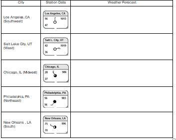
Answers
Answer:
Explanation:
did anyone get the answer
The place in South Africa where the significance of different slope elements for human activities located?
Answers
Answer:
The area in South Africa where the significance of different slope elements for human activities is particularly relevant is the Drakensberg region. The Drakensberg, also known as the Dragon Mountains, is a mountainous area located in the eastern part of South Africa, forming the eastern escarpment of the South African plateau.
The Drakensberg region is characterized by its dramatic landscapes, including steep slopes, rugged cliffs, deep valleys, and high peaks. These slope elements have significant implications for various human activities in the area:
1. Agriculture: The slopes of the Drakensberg present challenges and opportunities for agriculture. Terraced farming is practiced on the slopes to prevent erosion and make the land suitable for cultivation. The gradient and aspect of the slopes influence water availability, sun exposure, and soil erosion rates, which can impact crop choices and agricultural practices.
2. Tourism and Recreation: The scenic beauty of the Drakensberg attracts tourists and outdoor enthusiasts. The varying slopes provide opportunities for activities such as hiking, rock climbing, mountaineering, and paragliding. Different slope elements offer diverse experiences and levels of challenge for outdoor recreation.
3. Water Management: The slopes of the Drakensberg play a crucial role in water management. They act as catchment areas for rivers and streams, contributing to the water supply for both agriculture and urban areas. The steep slopes influence the flow patterns, erosion rates, and the formation of waterfalls and cascades.
4. Conservation and Biodiversity: The diverse slope elements in the Drakensberg support a rich array of plant and animal species. The steep cliffs and rocky slopes provide habitats for specialized flora and fauna, including endemic species. The conservation of these slopes is essential for preserving biodiversity and maintaining ecosystem services.
5. Settlements and Infrastructure: Human settlements and infrastructure in the Drakensberg region are influenced by slope elements. The gradient and stability of slopes affect the suitability of land for construction, road networks, and infrastructure development. Proper slope management and engineering practices are necessary to ensure safe and sustainable human habitation in the area.
Understanding the significance of different slope elements in the Drakensberg region is crucial for sustainable development, land use planning, conservation efforts, and risk management. It requires a holistic approach that considers the environmental, social, and economic factors associated with slope dynamics and their impact on human activities.
natural causes of tropical cyclone freddy
Answers
The natural causes and factors that contribute to the formation of tropical cyclones include:
Warm ocean watersLow vertical wind shearAtmospheric instabilityWhat is the tropical cyclone freddy?"Tropical cyclones, called hurricanes or typhoons, form under specific conditions, with warm ocean waters being a major contributing factor." Warm waters fuel tropical cyclones and low wind shear conditions are essential.
This promotes upward motion of air and important for tropical cyclone formation. The Coriolis effect is crucial for tropical cyclones' rotation and organization, initiated by Earth's rotation. Moisture and convergence fuel thunderstorm and cyclone formation.
Learn more about tropical cyclone freddy from
https://brainly.com/question/31445494
#SPJ1
When El Niño occurs and the waters off the coast of South America stay unusually warm, what happens to the sea life as a result?
Responses
A The flooding rains in Peru send too much water into the ocean and the sea life expands.The flooding rains in Peru send too much water into the ocean and the sea life expands.
B The sea life becomes overpopulated.The sea life becomes overpopulated.
C The upwelling of cold water in an El Niño provides perfect conditions for the fishing industry in the area.The upwelling of cold water in an El Niño provides perfect conditions for the fishing industry in the area.
D Many fish who depend on the upwelling of cold water die or migrate.
Answers
Answer:
D Many fish who depend on the upwelling of cold water die or migrate.
what is the effect of drainage basin and catchment area on people
Answers
The drainage basin and catchment area have significant effects on people via water supply, flood control, provision of ecosystem services, and land use planning considerations.
The drainage basin and catchment area, which refer to the geographical region where water drains into a specific water body, have several effects on people.
Water supply: The drainage basin and catchment area play a crucial role in providing a source of water for human use. Rivers and streams within these areas serve as freshwater sources for drinking, irrigation, and industrial purposes. People living within or near these regions depend on the water resources for their daily needs.
Flood control: The topography and land characteristics of a drainage basin affect the potential for flooding. The shape and slope of the catchment area determine how quickly water drains, which can either mitigate or exacerbate flooding risks. Communities residing in these areas need to consider flood control measures and infrastructure to protect lives and property.
Ecosystem services: Drainage basins and catchment areas support diverse ecosystems, including forests, wetlands, and wildlife habitats. These ecosystems provide essential services like water filtration, carbon sequestration, and recreational opportunities. People benefit from these services, such as clean drinking water, climate regulation, and recreational activities like fishing, hiking, and wildlife observation.
Land use planning: Understanding the boundaries of a drainage basin and catchment area helps in land use planning and resource management. It allows policymakers and communities to make informed decisions regarding land development, agriculture, and conservation practices. Proper land use planning in these areas can contribute to sustainable development and minimize negative impacts on the environment and human well-being.
In summary, the drainage basin and catchment area have direct effects on people through water supply, flood control, provision of ecosystem services, and land use planning considerations. Recognizing and managing these effects are crucial for sustainable water resource management and the well-being of communities.
For more questions on drainage basin
https://brainly.com/question/27330662
#SPJ8
Help please Global Medieval Europe

Answers
Greek democracy is the main idea of this passage. The correct option is D.
Why were the ancient Greeks important to democracy?The written constitution was a crucial idea from ancient Greece that had an impact on how the American republic was established. The Athenians' Constitution and the rules of many other Greek city-states were drafted and written down by Aristotle, or perhaps one of his students.
Global Medieval Europe refers to the interconnectedness of Europe with the wider world during the medieval period (approximately 500-1500 AD). Although many people tend to think of medieval Europe as a period of isolation and inward-looking development, in reality, Europe was connected to a wide variety of regions and cultures across the globe.
Thus, the ideal selection is option D.
Learn more about the ancient Greeks here:
https://brainly.com/question/5496193
#SPJ1
Which human activity negativetly affects the stabiltiy of the environment?
A. Recycling paper
B. riding bicycles
C. Cutting down all trees
D. Planting
Answers
Answer:
C.would be the most bestest answer
Explanation:
recycling is good, riding bikes is good instead of cars and emissions from them, and planting is excellent of course because your giving back to the environment.
so that leaves C :)