Suppose a future astronaut travels to a distance planet around a distant star. They collect rocks for dating the age of the planet and system. The astronaut compares the abundance of a certain radioactive element (half life of element = 500 million years) in the collected rocks to the abundance of the same element in a newly formed rock. They measure that there are 1/16th the number of radioactive atoms in the collected sample. How old is this planet?
a. 8 billion years old.
b. 4 billion years old.
c. 1 billion years old.
d. 2 billion years old.
e. 16 billion years old.
Answers
Answer:
The correct option is d
d. 2 billion years old.
Explanation:
The general formula to for the half life on an element is given as:
\(N(t)=N_o~ (\frac{1}{2})^{\frac{t}{t(1/2)}}\)
Where
N(t) = Quantity of the substance remaining.
N(o) = Quantity of the substance which was initially present
t = time elapsed
t(1/2) = half life of the substance
In this question, we have to find t using the above formula, where
N(t) = 1/16
N(o) = 1
t(1/2) = 500
Substitute in the given formula:
\(1=\frac{1}{16}~ (\frac{1}{2})^{\frac{t}{500}}\\\text{Solve the equation for t}\\t = 2000\)
Hence, the time planet has been into existence, or how old the planet is:
t = 2000 million years
or
t = 2 billion years
Related Questions
HELP ME PLS BEEN WORKING ON THIS QUISTION FOR 20 MIN
reflection , rotation , dilation , translation

Answers
Answer:
Reflection
Explanation:
Think of it as reflection in a mirror. I hope that makes it easier to remember.
What are the two most common religions in Africa? O A. Christianity and Islam O B. Christianity and Buddhism O C. Judaism and Christianity O D. Islam and Buddhism
Answers
Answer:
The answer is A ( Christianity and Islam)
Answer:
a
Explanation:
christianity and Islam is more in Africa but traditionalist are also there
1,write the sub-division of north-west and south-east highland of Ethiopia with associated lowlands?
Answers
Western Lowlands: Tekeze lowland, Abay-Dinder lowland, Baro lowland, and Ghibe lowland from north to south; The Tigray Plateau; North Central Massifs; The Shewan Plateau; Southwestern Highlands.
What are Ethiopia's principal highlands and lowlands?These are the Rift Valley, the Eastern Highlands, the Eastern Lowlands, and the Western Highlands and Western Lowlands. The largest and most rocky topographic region of Ethiopia is the Western Highlands. The North Central massifs, which make up the majority of the area and are the highest in Ethiopia, are the most spectacular.
What are Ethiopia's lowlands?Lowland areas in Ethiopia are those that are located below 1,500 metres. The brief for this rapid review was to concentrate primarily on the Afar and Somali regions, as well as the lowland parts of Oromia and SNNPR, even though they cover eight of the country's administrative regions.
To know more about Western Lowlands, visit:
brainly.com/question/1075147
#SPJ1
Mention and discuss any five Sustainable Development Goals ?
Answers
The Sustainable Development Goals (SDGs) are a set of global objectives adopted by the United Nations in 2015 to guide countries toward a more sustainable and equitable future. There are 17 SDGs in total. Here are five of them:
Goal 4: Quality Education: Ensure inclusive and equitable quality education for all. This goal aims to provide access to affordable and quality education at all levels, promote lifelong learning opportunities, and improve literacy rates. It recognizes education as a key driver of sustainable development and poverty eradication.Goal 7: Affordable and Clean Energy: Ensure access to affordable, reliable, sustainable, and modern energy for all. This goal targets the promotion of renewable energy sources, energy efficiency improvement, and expanding access to electricity, especially in developing countries. It emphasizes the importance of transitioning to clean energy to combat climate change and promote sustainable development.Goal 11: Sustainable Cities and Communities: Make cities and human settlements inclusive, safe, resilient, and sustainable. This goal focuses on creating sustainable urban environments by promoting affordable housing, improving urban planning, enhancing access to green spaces, and ensuring efficient transportation. It aims to create cities that are environmentally friendly, socially inclusive, and economically vibrant.Goal 13: Climate Action: Take urgent action to combat climate change and its impacts. This goal calls for global efforts to mitigate greenhouse gas emissions, adapt to climate change impacts, and strengthen resilience to climate-related disasters. It seeks to limit global temperature rise, enhance climate change education, and mobilize financial resources for climate action.Goal 16: Peace, Justice, and Strong Institutions: Promote peaceful and inclusive societies for sustainable development, provide access to justice for all, and build effective, accountable, and inclusive institutions. This goal focuses on reducing violence, promoting the rule of law, ensuring access to justice, and combating corruption. It recognizes the importance of effective governance, strong institutions, and peaceful societies for sustainable development.These five SDGs represent a small subset of the broader agenda, highlighting the interconnectedness of the social, economic, and environmental aspects of sustainable development. Achieving these goals requires collective action, partnerships, and policy reforms at the global, national, and local levels.
will give brainliest!
Which of the following best reflects the location of early settlements in the United States?
1.In mountainous areas where there were deposits of gold and silver
2.Far from the coast in order to avoid attacks by French and Spanish ships
3.In deep forests where there were large supplies of timber
4.On the coast and along rivers to provide access to transportation
Answers
Answer:
4.On the coast and along rivers to provide access to transportation
Explanation:
The location of early settlements in the United States occur on the coast and along the rivers because the people comes from the great Britain through sea and they settle on the coast in order to access transportation. All southern colonies of United States that is located along the sea were colonized by the people comes from great Britain in order to get benefit from the new land and this location provides the transportation to the people.
write a peel paragraph about Italy population issue
Answers
Answer:
i don't know about italy but i can look more into that for u
Explanation:

Which of the following is NOT a shared characteristic of a state?
a- Defined territory
b- Permanent population
c- Sovereign
d- Language
Answers
Answer:
Correct answer is b- Permanent population .
Explanation:
Option A is not correct as every state needs to have a defined territory, which is established in a certain period.
B is correct as population of country changes due to different reasons, including for example the migrations.
C is not correct as every country has its leadership. For example, if it is a monarchy, it has a unique monarch (king).
D is also correct as every country has its official language.
migration begins at the area called
Answers
Migration begins at the area called the point of origin.
What is the starting point for migration?The point of origin is the initial location from where a migratory journey begins. It serves as the starting point for individuals or groups of organisms as they embark on their seasonal or long-distance movements. This area is typically characterized by favorable conditions, such as abundant resources or suitable breeding grounds that trigger the need for migration.
It acts as a launching pad for migratory routes and plays a crucial role in determining the direction and timing of the migration. The point of origin can vary on species or context, ranging from specific breeding sites for birds to specific regions for human migration patterns.
Read more about migration
brainly.com/question/18259786
#SPJ1
How many tonnes of carrot do china make annually
a) 21,482,971
b) 120,900,355
c) 10,470,555
d) 1,190,830
Answers
Answer:
a) 21,482,971
China is the largest carrot and turnip producer in the world with 21,482,971 tonnes production per year.
Explanation:
Hope this helps
using practical examples, discuss how five economic planning instruments can be applied to enhance the environmental sustainability of cape coast metropolitan in four pages.
Answers
"Introduction
Cape Coast Metropolitan is one of the largest cities in Ghana with a population of about 170,000 people. It is located in the Central Region and has a significant impact on the environment due to human activities. As such, environmental sustainability is a crucial concern for the metropolitan area. This paper will discuss five economic planning instruments that can be applied to enhance environmental sustainability in Cape Coast Metropolitan.
1. Environmental Impact Assessment (EIA)
Environmental Impact Assessment is a planning tool used to assess the potential environmental impact of proposed projects. EIA provides an opportunity to identify potential environmental risks and propose mitigation measures to avoid or minimize adverse environmental impacts. In Cape Coast Metropolitan, EIA can be used to assess the potential environmental impacts of development projects such as construction of buildings, roads, and other infrastructure. For example, before the construction of a new housing project, an EIA can be conducted to assess the potential impact on the environment, including air and water pollution, loss of biodiversity, and land degradation. The EIA can identify potential mitigation measures such as the use of green building techniques, the implementation of waste management plans, and the protection of natural habitats.
2. Environmental taxes
Environmental taxes are levies imposed on activities that have a negative impact on the environment. In Cape Coast Metropolitan, environmental taxes can be used to discourage activities that contribute to environmental degradation. For example, a tax can be imposed on industries that emit pollutants into the air or water. The tax can provide an incentive for industries to adopt cleaner production methods that reduce the emission of pollutants. Additionally, a tax can be imposed on the use of non-biodegradable materials such as plastics. The tax can provide an incentive for individuals and businesses to switch to more environmentally friendly alternatives such as reusable bags.
3. Tradable permits
Tradable permits are a market-based instrument that can be used to limit the amount of pollution emitted by industries. Under this system, the government sets a limit on the amount of pollution that can be emitted by an industry. The industry is then issued a number of permits equal to the allowable amount of pollution. If an industry emits less pollution than its allocated permits, it can sell the surplus permits to other industries that exceed their permitted emissions. In Cape Coast Metropolitan, tradable permits can be used to limit the amount of pollution emitted by industries such as manufacturing and transportation. This can encourage industries to adopt cleaner production methods and reduce their emissions to stay within their allocated permits.
4. Subsidies
Subsidies are financial incentives provided by the government to encourage certain activities. In Cape Coast Metropolitan, subsidies can be used to promote environmentally friendly activities such as the use of renewable energy sources. For example, the government can provide subsidies to individuals and businesses that install solar panels or wind turbines. This can encourage the adoption of renewable energy sources, which can reduce the reliance on fossil fuels and the emission of greenhouse gases. Additionally, the government can provide subsidies for the development of public transportation systems such as buses and trains. This can encourage the use of public transportation, which can reduce the emission of pollutants from private vehicles.
5. Green procurement
Green procurement is a policy that encourages the purchase of goods and services that have a lower environmental impact. In Cape Coast Metropolitan, green procurement can be used to promote sustainable consumption patterns. For example, the government can adopt a policy of purchasing office supplies that are made from recycled materials. Additionally, the government can encourage the purchase of locally produced goods and services, which can reduce the emission of greenhouse gases associated with transportation. Green procurement can also be applied to construction projects, where the government can require the use of environmentally friendly building materials.
Conclusion
In conclusion, environmental sustainability is a critical concern for Cape Coast Metropolitan. The city can use a range of economic planning instruments to enhance environmental sustainability. These instruments include environmental" (ChatGPT, 2023)
Find the volume of the prism
A. 240ft
B. 343ft
C. 251ft
D. 232ft

Answers
Answer: B
Explanation:
The area of this prism is base x height , which is 49 * something. The volume must be divisible by 49, so the answer is B
Answer:
B
Explanation:
Just multiply 7 by 7 by 7 or 7 to the 3rd power and you get 343
15. What is the most important social unit in Saudi society?
O the village
O the nation
O the family
O the workers
Please help me out guys
Answers
Answer
the family
I think this is correct answer
What is the goal of welfare capitalism practiced in Northern Europe?
Answers
Answer:
Welfare capitalism provided social programs to help worker's rights and also to increase worker production and economic development.
11) A map is being reviewed by you and your colleagues. A broad ridge runs from the southwest comer to the
northeast corner of the map. The map legend indicates old rocks in the center of the ridge with the age
of the rocks becoming progressively younger away from the center of the ridge. This feature is
interpreted by you as a) an anticline b) a syncline c) a spreading center d) a uniformly digressing
strain meter
Answers
Answer:
ljkk
Explanation:
ghkghkjh
maps can show more then the veiw outside your window such as?
A.political boundries
B.elavations
C.population characteristics
D.all of the above
Answers
hope that helps
A grain bin consists of a cone stacked on top of a cylinder, where the radii of the cone and the cylinder are equal. The diameter of the cylindrical base of the grain bin is 12 ft and the height of the cylinder is 10 ft, while the height of the cone is 8 ft. Calculate the surface area of the grain bin. Leave your answer in terms of π.
Answers
Answer:
216π sq ftStep-by-step explanation:given that :d = 12 ft => r = 12/2
Explanation:
for grain bin consists of a cone stacked on top
Cuba Jamaica and hispaniola are all part
a. Bahamas
b. virgin islands
c. lesser antilles
d. greater antilles
Answers
Scientists can locate the ________ of an Earthquake by noticing the time and direction of the Earthquake at different points on Earth
Answers
A point on the earth's surface is above the point where an earthquake occurs.
20 Points
Candidates who do not declare themselves as a member of a particular party are _____?
Answers
Answer:
independent
Explanation:
An independent or nonpartisan politician is a politician not affiliated with any political party. There are numerous reasons why someone may stand for office as an independent. Also George Washington was an independent.
How is the crust and inner core different
Answers
Answer:
They are both different layers and what makes up both crust and the inner core are very different. they are so different because the inner core is hotter and melts down the soil and rock making the sediments different
Explanation:
What are the benefits of recycling ?
Answers
Why do natural borders affect people and places ? Use an Example
Answers
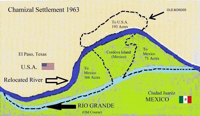
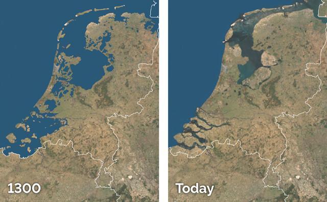
Natural borders tend to change due to climate and other causes. Natural borders that are formed around mainly rivers and lakes, to some extent ocean have the largest effects on people. An example of river one is the Natural border of the Rio granda river that borders the states of Texas and Mexico. The change in the Rio granda river caused texas to lose 367 acres of land to Mexico and caused commotion among the US citizens now living in Mexico due to the change of the River. Another example is the flooding of holand in the Netherlands in the past. Due to rising sea levels areas of Holand netherlands are being flooded which effects people and places
a physical geographer might designate regoins based on
Answers
A physical geographer might designate regions based on Optio B. continents, mountains, and bodies of water.
This approach focuses on the physical characteristics of the Earth's surface and how they influence the distribution of landforms, climate patterns, and natural resources. By considering these physical features, geographers can identify distinct regions with unique characteristics and processes.
Continents play a significant role in regional designation as they are large landmasses separated by oceans. Each continent has its own set of physical features, such as mountain ranges, rivers, and deserts, which contribute to the formation of distinct regions. For example, the continent of Africa is known for its vast savannahs, while South America is home to the Amazon rainforest and the Andes Mountains. These physical features shape the climate, vegetation, and animal life in these regions.
Mountains also contribute to regional designation as they create barriers that affect climate and vegetation patterns. For instance, the Himalayas in Asia have a profound impact on the monsoon system and the distribution of precipitation across the region. Mountains can also act as natural borders between regions, influencing cultural and economic interactions.
Bodies of water, such as oceans, seas, and lakes, also play a crucial role in regional designation. They affect climate, provide transportation routes, and influence economic activities like fishing and trade. For instance, the Mediterranean Sea has shaped the climate and cultural development of the surrounding countries, creating a distinct region known as the Mediterranean Basin.
Overall, by considering continents, mountains, and bodies of water, physical geographers can identify regions based on the natural characteristics and processes that shape the Earth's surface. This approach helps in understanding the relationships between physical features, climate, ecosystems, and human activities within different regions. Therefore, Option B is Correct.
Know more about the Physical geographer here:
https://brainly.com/question/13563076
#SPJ8
The question was Incomplete, Find the full content below:
A physical geographer might designate regions based on:
A. historical human migrations.
B. continents, mountains, and bodies of water.
C. ages of civilizations.
D. languages are spoken.
a coastal feature form as a result of the roof of an arch that has collapsed is
Answers
Answer:
a stack
Explanation:
when the arch collapses it leaves a stack( the waves erode this over time so the stack will later become a stump).
The order is basically cave,then arch, then stack and finally stump.
Which cultural icon of Australia is represented in the photo above?
A. billy tea and damper
B.
a stockman
C.
a swagman
D. a Pakeha

Answers
Answer:
the answer is B " a stockman"
Explanation:
i took the test and got it right
Answer:
B
Explanation:
A stockman, first, I got it right, second, a stockman is a person that tends to animals.
suggest 3 intervention strategies that can be implemented to decrease rural urban migration
Answers
Intervention strategies can help address the root causes of rural-urban migration and create more opportunities for people to stay in rural areas. There are 3 intervention strategies is:
Boost local revenue.Reduce local income inequality.Increase cultivatable.Increase local revenue growth and social facility development: According to a study, efforts should be taken to increase local revenue growth and social facility development in order to prevent rural-urban migration.
Boost local revenue growth and social facility development: According to a study, efforts should be taken to boost local revenue growth and social facility development in order to prevent rural-urban migration.
Reduce inequity in local income: According to new research, addressing local income disparity may limit rural-urban migration.
According to new research, decreasing local income disparity may limit rural-urban migration.
Increase cultivatable land and equalize land or income distribution: Interventions that increase cultivatable land, equalize land or income distribution, or reduce fertility may reduce rural-urban migration.
As a result, the significance of the intervention strategies that can be implemented to decrease rural urban migration are the aforementioned.
Learn more about on intervention strategies, here:
https://brainly.com/question/31673603
#SPJ1
Why were suspension bridges important in the Inca empire
Answers
Answer:Suspension bridges were important in the Inca Empire because they allowed for easier travel and transportation of goods, as well as providing an advantage in military strategy.
Explanation:
The Inca Empire was an ancient civilization that flourished in South America from the 13th to the 16th century. The Inca people were known for their advanced engineering and infrastructure, including their impressive network of suspension bridges.
Suspension bridges were crucial in the Inca Empire because they helped connect different regions of the empire and allowed for easier travel across difficult terrain. The Inca people were skilled in weaving ropes and cables from natural materials like grass and straw, which they used to construct the bridges.
One famous example of an Inca suspension bridge is the Q'eswachaka Bridge, which is still standing today in modern-day Peru. This bridge was built using traditional Inca techniques and is made entirely of woven grass and straw cables. It stretches over 100 feet across a deep canyon and is still used by locals today.
Suspension bridges also played an important role in the Inca Empire's military strategy, as they allowed troops to quickly cross rivers and valleys during battle. They were also used to transport goods like crops, textiles, and precious metals across the empire.
Suspension bridges were important in the Inca Empire because they allowed for easier travel and transportation of goods, as well as providing an advantage in military strategy. The Inca people's impressive engineering skills helped them construct these impressive structures, which continue to amaze and inspire us today.
temperature and pressure combine to keep the outer core in a
Answers
Answer:
Liquid state
Explanation:
Troubleshooting differs from diagnosis in that
Answers
Answer:
]troubleshooting focuses on how to fix the problem
Explanation:
Answer: troubleshooting focuses on how to fix the problem
Explanation: took the quiz
Ver en español
Jackson loves to take day trips during weekends. Last weekend, he drove 80 miles to Crabclaw Beach. He used 4 gallons of gas to get there. This weekend, he will drive 100 miles to get to Mount Highmore.
If he uses gas at the same rate, how many gallons of gas will Jackson use to get to Mount Highmore?
gallons
Answers
Answer:
Explanation:
If Jackson used 4 gallons of gas to drive 80 miles to Crabclaw Beach, we can calculate his gas mileage as follows:
Gas mileage = distance / gas used
Gas mileage = 80 miles / 4 gallons
Gas mileage = 20 miles per gallon
Using this gas mileage, we can calculate how many gallons of gas Jackson will use to drive 100 miles to Mount Highmore:
Gas used = distance / gas mileage
Gas used = 100 miles / 20 miles per gallon
Gas used = 5 gallons
Therefore, Jackson will use 5 gallons of gas to get to Mount Highmore if he uses gas at the same rate as he did for his trip to Crabclaw Beach.