Please Help I need this done
(Question 1) A developed country is more likely to exhibit more of the following levels of economic activities?
a. Secondary and Quatemary
b. Tertiary and Quatemary
c. Primary and Tertiary
d. Primary and Secondary
(Question 2) When geographers study the moraines of Minnesota they can conclude that?
a. A gladcier once covered the area
b. Chemical weathering has occurred
c. A volcano erupted there
d. A fault lies nearby
Answers
Answer:
Question 1. b. Tertiary and Quaternary
In developed countries, the tertiary sector, consisting of services such as tourism, hotels, restaurants, healthcare, and education, and the quaternary sector, consisting of sectors like research, information technology, and advanced intellectual activity, tend to be the most important econoimc sectors, because developed countries will have already made the transition from an agricultural economy, to an industrial economy, to a service-based, and intellectual-based economy.
Question 2. a. A gladcier once covered the area
The moraines of Minnesota are a hilly region in the center and in the northeast of Minnesota. The moraines were formed by glaciers, that once covered the area, in several stages, leaving the hilly landscape, and also several shallow lakes that populate the region.
Related Questions
Please help.
Assess whether the social impacts of climate change experienced in the UK in the 21st century are greater than the environmental impacts.
Point: yes they are.
Evidence: (use the ulez zone as an example)
Explanation: why is this so important?
2nd point: No they are not.
Evidence:
Explanation: why is this so important?
I have an hour to submit this.
Answers
The impacts of climate change experienced in the UK in the 21st century are both social and environmental. While both impacts are significant, the social impacts are arguably greater. For example, in 2019 the UK introduced the Ultra Low Emission Zone (ULEZ) in London, which has had a significant social impact on the city. The ULEZ has increased the cost of operating vehicles in the city, with the intention of reducing emissions. This has had a significant impact on the social dynamics of the city, with many low-income households feeling the financial burden of the ULEZ. Additionally, the ULEZ has led to an increase in public transport use, which has had a knock-on effect on many businesses and services that rely on car use. These social impacts are arguably more significant than the environmental impacts, as the ULEZ has only had a limited effect on reducing emissions. Therefore, it can be argued that the social impacts of climate change experienced in the UK in the 21st century are greater than the environmental impacts.
Define physical properties and give 3 examples.
Answers
Answer:
Properties that do change tha chemical nature of matter. Examples of physical properties are: color, smell, freezing point, boiling point, melting point, infra-red spectrum, attraction (paramagnetic) or repulsion (diamagnetic) to magnets, opacity, viscosity and density. There are many more examples.
hope this helps you :)
Based on your knowledge of Latin America, which conclusion regarding human interaction with
the environment is accurate?
A Most urban centers are located in the interior.
B Ranching and herding is the chief industry of Peru.
C Commercial farming occurs mostly along the coasts.
D Much of the Brazillian forestry industry uses the Amazon River.
Answers
Answer:D
Explanation:
Brazilian forest uses the amazon river
humans interaction with environment
The conclusion regarding human interaction with the environment that is accurate is "much of the Brazillian forestry industry uses the Amazon River".
The Amazon rainforest is the largest intact forest on the planet. In Brazil alone, it is home to more than 24 million people, including hundreds of thousands of Indigenous Peoples from 180 different groups.
In addition to its unparalleled diversity of life, the Amazon plays an important role in environment control. The rainforest contributes approximately $8.2 billion to the Brazilian economy each year through products such as rubber and timber.
The correct answer is option D.
Know more about Amazon River here
https://brainly.com/question/17830450
#SPJ1
Which three religions all originated in India?
Answers
Answer:
Hinduism , Buddhism, Sikhism
Explanation:
all 3 of theese religions originated in india ad hinduishm nd Buhdism are still comonly practiced today.
Hope this helps!
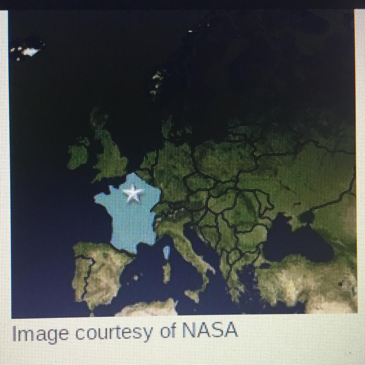
Identify the correct capital city of the country highlited on the map above.
Answers
Answer:
Paris
Explanation:
This country is France, and the capital of France is Paris
meaning of navigable
Answers
Answer:
it means in Hindi जहाज़ रानी का
What map shows that the Himalayan mountains are the highest in the world
Answers
Answer:
if you look at a topographic map of the world or will more than likely show it
why do stars create rainbows of light?
Answers
Answer:
the temperature of the star causes it to change color .
Explanation:
the color of a star is linked to its surface temperature . the hottest ones are blue or blue-white, which are shorter wavelengths of light. the colder ones are red or red-brown, which are longer wavelengths .
What is another animal that might have a larger than natural population because of human impact? Explain your reasoning.
Answers
Cows are probably an animal that is overpopulated because of the human species. This is happening because people need cows for what they can offer, such as milk or even food as a result they keep pushing the limits to get the most out of these animals.
Various animals might have a larger than natural population because of human impact; one is a domestic dog.
Through the human activities of using dogs as a pet, the population of dogs might have a larger than natural population.
The reason is simple, the demand for the dogs as pets would make humans breed dogs, thereby ensuring dogs have more births than a natural occurrence.
This is evident in a recent research survey conducted among pet owners.
It was revealed in 2017 that there are about 89.7 million domestic dogs in the United States.
This number revealed a 20 million increase in domestic dogs population compared to 68 million domestic dogs in 2000.
Hence, in this case, it is concluded that some human activities can positively impact the animal population.
Learn more here: https://brainly.com/question/3768323
The Carlisle Indian Industrial School is an example of
O Acculturation
O Diffusion
O Appropriation
O Assimilation
Answers
The Carlisle Indian Industrial School is an example of acculturation.
What is acculturation?This is a situation, where one blends with certain culture. Here, as one get used to the culture, lots of things are being learnt like what people usually do in specific situations or events
Hence, the Carlisle Indian Industrial School is an example of acculturation.
Learn more about acculturation here : https://brainly.com/question/10799789
#SPJ1
Which of the following are good seal rocks within an oil field?
fractured granite
fine grained limestone
shale
sandstone
Answers
The good seal rocks within an oil field are shale and fine-grained limestone.
Shale and fine-grained limestone are good seal rocks within an oil field because they have low permeability, meaning they do not allow oil to easily flow through them. Shale is composed of tiny particles that have been compacted over time, creating a dense, impermeable rock. Fine-grained limestone has a similar composition, with small particles that fit tightly together to prevent fluid movement. Fractured granite and sandstone, on the other hand, are not good seal rocks because they have higher permeability and can allow oil to escape through cracks or pores. Therefore, shale and fine-grained limestone are preferred as seal rocks in oil fields to prevent oil from migrating and becoming lost.
Learn more about fine-grained limestone: https://brainly.com/question/6378171
#SPJ11
Refer to your answers to the SoCal Mountains and Basins lab. The Transverse Ranges were likely formed by which of the following geologic structures? Choose ALL that apply. normal faults strike-slip faults reverse (and thrust) faults folds
Answers
In the SoCal Mountains and Basins lab, we learned about the geologic features of Southern California, including the Transverse Ranges. These ranges are a series of mountain ranges that run east-west across the southern part of the state. The question asks which geologic structures were likely responsible for the formation of the Transverse Ranges, and gives several options to choose from.
One possible answer is normal faults. Normal faults occur when two blocks of rock move away from each other, creating a gap or a rift between them. This type of faulting is common in areas where the Earth's crust is being pulled apart, such as in the Basin and Range Province of the western United States. However, normal faults are not likely to have played a significant role in the formation of the Transverse Ranges. Another possible answer is strike-slip faults. These faults occur when two blocks of rock move horizontally past each other, such as along the San Andreas Fault in California. While the Transverse Ranges are located near the San Andreas Fault, they are not believed to have formed directly as a result of strike-slip faulting.
In summary, the Transverse Ranges were likely formed by reverse (and thrust) faults, as a result of compression in the Earth's crust. While other geologic structures, such as folds and strike-slip faults, may have played a role, they are not believed to be the primary cause of the mountain ranges.
To know more about geologic visit:-
https://brainly.com/question/20592516
#SPJ11
Rank the sediment transport process in terms of grain size, with the finest on top and the coarsest on the bottom. 1. Sediment is carried in suspension
2.Sediment is transported through saltation and bounces along the surface
3.Sediment rolls across the surface of the ground
4.Sediment is not transported at all but remains stationary
Answers
The sediment transport process in terms of grain size, with the finest on top and the coarsest on the bottom will be Sediment transported through saltation followed by sediment carried in suspension followed by sediment rolling across the surface and at the end sediment that remains stationery
What are Sediments?
Sediment is a naturally occurring substance that is broken down by weathering and erosion processes and then moved by the force of gravity acting on the particles or by the action of wind, water, or ice. Solid material that has been transferred and dumped in a new location is known as sediment. Rocks, minerals, and animal and plant remains can all be found in sediment. It can range in size from a boulder to a single sand grain. Through the process of erosion, sediment is transferred from one location to another. Sandstone, limestone, and shale are examples of typical sedimentary rocks. These rocks frequently begin as sediments that are transported by rivers, then are dumped in lakes and oceans.
Hence, The sediment transport process in terms of grain size, with the finest on top and the coarsest on the bottom will be Sediment transported through saltation followed by sediment carried in suspension followed by sediment rolling across the surface and at the end sediment that remains stationery
To learn more about Sediments click,
https://brainly.com/question/329212
#SPJ4
can someone help me pls with my work here is the website https://www.worldometers.info/demographics/demographics-of-europe/ to help you find the information to answer the questions

Answers
Answer:
no identity will escape! I know where you live
topography dominated by depressions formed by the collapse of caves is termed a . group of answer choices valley and ridge province karst landscape horst and graben landscape speleothem formation
Answers
The term used to describe a topography dominated by depressions formed by the collapse of caves is "karst landscape". This type of landscape is characterized by soluble rocks such as limestone, dolomite, or gypsum that have been dissolved by water, resulting in the formation of underground caves and channels. Over time, the roofs of these underground spaces can collapse, leaving behind depressions or sinkholes on the surface.
Karst landscapes can be found all over the world, from the Yucatan Peninsula in Mexico to the Dinaric Alps in Europe. They are known for their unique features, such as disappearing streams, underground rivers, and cave systems.
Finally, "speleothem formation" refers to the process by which mineral deposits form inside caves. These deposits can take the form of stalactites, stalagmites, and other unusual shapes. Speleothem formation is a common feature of karst landscapes, but can also occur in other types of caves.
In summary, the term used to describe a topography dominated by depressions formed by the collapse of caves is a karst landscape.
To know more about topography visit:-
https://brainly.com/question/15924652
#SPJ11
the equilibrium theory of island biogeography predicts that large islands close to the mainland will have more species than small islands that are distant from the mainland.
Answers
yes, the statement is correct. The equilibrium theory of island biogeography predicts that larger, closer islands to the mainland have more species than smaller, more distant islands.
According to Robert MacArthur and E.O. Wilson's equilibrium theory of island biogeography, larger islands that are closer to the mainland will have greater species diversity than smaller islands that are farther away. The interaction between immigration and extinction rates forms the foundation of this theory. Due to their larger target areas and closer proximity to the mainland source pool, larger islands have a greater capacity to receive migrant species.
Additionally, larger islands typically support more diverse and abundant habitats, which lowers the risk of local extinctions. Smaller islands, on the other hand, have more difficulty sustaining viable populations and attracting new species, which results in a lower diversity of species. The equilibrium theory which has gained empirical support in numerous island systems around the world offers insightful explanations of the factors affecting island biogeography.
Learn more about equilibrium theory at:
brainly.com/question/30359048
#SPJ4
the complete question is "is the statement correct 'the equilibrium theory of island biogeography predicts that large islands close to the mainland will have more species than small islands that are distant from the mainland. explain."
From a soil science perspective, what criteria are most important for classifying sedimentary rocks?
Answers
Sedimentary rocks are classified based on how they form and on the size of the sediments, if they are clastic. Clastic sedimentary rocks are formed from rock fragments, or clasts; chemical sedimentary rocks precipitate from fluids; and biochemical sedimentary rocks form as precipitation from living organisms.
What are Sedimentary rocks?
The formation of sedimentary rocks involves the accumulation or deposition of mineral or organic particles at the Earth's surface, followed by cementation. The mechanisms that lead to the accumulation of these particles are collectively referred to as sedimentation.
Therefore,
From a soil science perspective, what criteria are most important for classifying sedimentary rocks?
Sedimentary rocks are classified based on how they form and on the size of the sediments, if they are clastic. Clastic sedimentary rocks are formed from rock fragments, or clasts; chemical sedimentary rocks precipitate from fluids; and biochemical sedimentary rocks form as precipitation from living organisms.
To learn more about Sedimentary rocks from the given link:
https://brainly.com/question/7437433
#SPJ4
what is the name of the significant port located along the mississippi river close to the gulf of mexico?
Answers
The name of the significant port that is located along the Mississippi River and closer to the Mexican Gulf is the Gulf of New Orleans.
The Gulf of New Orleans is among the most geographically significant ports in the American part of the world. It acts as a great connectivity between the America and other parts of the world. Moreover, being close to the Mississippi River has also helped to develop trade along this port, added to the benefits it receives by being very closer to the Gulf of Mexico.
Learn more about Gulf of New Orleans here:
https://brainly.com/question/4932683
#SPJ4
According to the table, which country is most likely to offer financial assistance to countries with struggling economies in the
European Union?
A) Bulgaria
B) Romania
C) Greece
D) Germany

Answers
Germany
They have the best stats — more chance they will help other struggling countries
According to the table, Germany is most likely to offer financial assistance to countries with struggling economies in the European Union. The correct option is D.
What is the importance of economic development to poor countries?The goal of economic development is to raise the absolute level of per capita income to improve material standards of living. Raising per capita incomes is a stated policy goal of all developing-country governments.
Wealthy nations can also take positive steps that directly benefit developing countries, such as taking action against corrupt leaders, assisting with research and development, and improving global labor mobility. Governance is the most difficult challenge for countries in the world's poorest regions, particularly in Africa.
Thus, the ideal selection is option D.
Learn more about economic development here:
https://brainly.com/question/1645709
#SPJ2
15. According to the U.S. Environmental Protection Agency (EPA), spoils from
than 700 miles of streams.
a. subsurface mining
b. mountaintop removal
c. contour strip mining
d. open-pit mining
e. area strip mining
Answers
Answer:
Not sure but I think its Mountain Top Removal
The earth axis showing the tilted
Answers
Answer:
?>>>>>>>>>>>>>>>>>>>>>>>>>
solutional erosion below the surface in areas underlain by soluble rock such as limestone and gypsum creates distinct features at the surface known as .
Answers
Answer:
Karst features
Explanation:
Karst features are created by solutional erosion below the surface in areas underlain by soluble rock such as limestone and gypsum. These features include sinkholes, dolines, springs, and caves.
3-5 sentences of background information on geography
Answers
Angola is capable of producing 700 pounds of salt or 50 pounds of pepper or some combination of the two. Benin is capable of producing 600 pounds of salt or 30 pounds of pepper or some combination of the two. Describe a trade that would benefit both countries. Which country produces each good? And how much of one should be traded for the other? Clearly show why this trade would benefit both countries. You only need to do this problem once. Even if you redo and resubmit the assignment, you don't need to repeat this question unless you want to change your answer.
Answers
Answer:
To determine a trade that would benefit both Angola and Benin, we need to compare their production capabilities and identify a scenario where they can specialize in producing the good they have a comparative advantage in.
Explanation:
To determine a trade that would benefit both Angola and Benin, we need to compare their production capabilities and identify a scenario where they can specialize in producing the good they have a comparative advantage in.
Angola can produce 700 pounds of salt or 50 pounds of pepper, while Benin can produce 600 pounds of salt or 30 pounds of pepper.
To find the comparative advantage, we need to compare the opportunity costs of producing salt and pepper in each country. The opportunity cost is the value of the next best alternative that must be forgone when making a choice.
For Angola:
Opportunity cost of producing 1 pound of salt = 50 pounds of pepper
Opportunity cost of producing 1 pound of pepper = 1/50 pound of salt
For Benin:
Opportunity cost of producing 1 pound of salt = 20 pounds of pepper
Opportunity cost of producing 1 pound of pepper = 1/20 pound of salt
Comparing the opportunity costs, we can see that Angola has a comparative advantage in producing salt, as the opportunity cost of producing salt (1/50 pound of pepper) is lower than that of Benin (1/20 pound of pepper).
Conversely, Benin has a comparative advantage in producing pepper, as the opportunity cost of producing pepper (1/20 pound of salt) is lower than that of Angola (1/50 pound of salt).
To benefit both countries through trade, Angola should specialize in producing salt, and Benin should specialize in producing pepper. They can then exchange their surplus goods with each other.
Let's assume they decide to trade 1 pound of salt for pepper. Angola can produce 700 pounds of salt, which means it can trade 700 pounds of salt for (700 * 1/50) = 14 pounds of pepper. Benin can produce 30 pounds of pepper, so it can trade 30 pounds of pepper for (30 * 50) = 1500 pounds of salt.
By engaging in this trade, Angola receives 14 pounds of pepper (which it couldn't produce efficiently), while Benin receives 1500 pounds of salt (which it couldn't produce efficiently). Both countries gain access to goods they have a comparative disadvantage in producing, leading to an increase in overall welfare and benefiting both nations.
Which of the following courses would be most closely related to a career as a range land management specialist?
Exotic Species
Diversity of Life
Land Restoration Management
Over hunting and its Effects on the Ecosystem
Answers
you are given the map in figure f1 below. note the red line that demarcates the center of the rio grande in 1936 and that the blue channel is the river's position in 1992. because this section of the river is a nearly level plain and average annual flow varies widely, the river migrates across the floodplain. since the center of the river is the international boundary, any such movement impacts this densely populated bi-national floodplain. study the map to evaluate which of the following statements is not true.
Answers
The Rio Grande, which runs from the twin cities of El Paso, Texas, and Ciudad Juárez, Chihuahua, to the Gulf of Mexico, has served as the border between Mexico and the United States since 1848.
The main usage of water from the Rio Grande has always been for agricultural purposes. Currently, agriculture is given access to 75% of the water. Divergent plate boundary pressures in the western section of the continent are starting to rip it apart, creating the Basin and Range Province and its adjacent eastern arm, known as the Rio Grande Rift. Natural landscape elements like rivers, lakes, and mountains serve as physical boundaries. A significant physical boundary on the American continent's southern border is the Rio Grande. The area is well-known for its tropical climate, rare birds, citrus groves rivers, and abundance of palm palms. Many retirees from the North American countries of the United States and Canada come to Florida during the winter because of the pleasant rivers. Mexican nationals are drawn there all year long because of the wonderful shopping options that are abundant there. "The Rio Grande Valley is not a valley physically or geologically. The historian T.R. Fehrenbach, who was born in the "valley," described it as a delta "San Benito town. He surmised that the term Rio Grande Valley was first used by early Anglo settlers in the region because they thought "valley is a prettier word."
Learn more about Rio Grande here:
brainly.com/question/1407351
#SPJ4
Please help :(( please please i give brainliest and 5 star.
Task 2 and Task 3 please

Answers
Answer:
Secure Water for People and Nature
Less than 1% of the world's water is fresh and accessible. WWF works with governments, businesses, international financial institutions and communities to ensure healthy freshwater systems exist to conserve wildlife and provide a sustainable future for all
HEY THERE!HERE IS UR ANSWER:
1)A national park is a park in use for conservation purposes, created and protected by national governments.National parks provide a safe home for native plants and animals. They help keep the air and water clean. These are places where "non-intervention" prevails and where the principle is to allow the free evolution of natural processes. Example:Hot Springs National Park.
2)The World Wide Fund for Nature (WWF) is an international non-governmental organization.WWF works with governments, businesses, international financial institutions and communities to ensure healthy freshwater systems exist to conserve wildlife and provide a sustainable future for all.
Sorry but U need to do task 3 by yourself as it is a research. I am really sorry!
HOPE IT MAKES YOUR DAY BETTER!!
27.what is magmatic differentiation? what does it explain? what happens during magmatic differentiation?
Answers
The term "magmatic differentiation" refers to any process that modifies magma's original composition. A variety of rock types are formed when a single, homogeneous magma undergoes the process of magmatic differentiation, in which it splits into two or more portions of distinct composition.
Physical separation of the first crystals that form from the remaining magma, either by sinking to the bottom of a magma chamber or by being forced out to cool due to crustal deformations, is another mechanism by which magma can undergo differentiation. The observed compositional change of magma within relatively small regions has been attributed to a number of different processes over the years. There are a number of processes including:
Distinct melting events from distinct sources.Various degrees of partial melting from the same source.Crystal fractionation.Mixing of 2 or more magmas.Assimilation/contamination of magmas by crustal rocks.Liquid Immiscibility.To learn more about magma differentiation, click here:
https://brainly.com/question/28103962
#SPJ4
In which region would you be the most likely to find and keep a
diamond
Answers
Southern Africa, is the region for the most likely to find and keep a diamond.
The most likely region to find and keep a diamond is in areas with significant diamond deposits, particularly in diamond-rich geological formations. One such region is Southern Africa, specifically countries like Botswana, South Africa, Namibia, and Angola. These countries are known for their diamond mines and have significant diamond reserves.
Southern Africa is home to the world's largest diamond producer, Botswana, where the Orapa and Jwaneng mines are located. South Africa is historically renowned for its diamond mining industry, with famous mines like the Kimberley mine. Namibia is known for its offshore diamond deposits, and Angola has significant diamond resources as well.
The presence of diamonds in these regions can be attributed to geological processes involving volcanic activity and the movement of tectonic plates. Diamonds are typically found in kimberlite and lamproite pipes, which are formed deep within the Earth's mantle and are brought to the surface through volcanic eruptions.
It is important to note that diamond mining and ownership are regulated, and the ability to keep a diamond legally would require adherence to applicable laws and regulations, as well as compliance with ethical considerations such as avoiding conflict diamonds or supporting responsible sourcing practices.
Know more about Diamond here:
https://brainly.com/question/26765232
#SPJ8
find the latitude and longitude of the location on earth precisely opposite of a town located at latitude 47 s , longitude 101w .
Answers
Answer:
Explanation:
La ubicación exactamente opuesta a un pueblo ubicado en la latitud 47 S, longitud 101 W se encuentra en la latitud 47 N y longitud 79 E . La latitud es el ángulo entre el plano ecuatorial y la línea que pasa por este punto y el centro de la Tierra. Todos los puntos con la misma latitud forman un plano paralelo al plano del ecuador . La longitud es el ángulo entre un plano de referencia (el plano del meridiano de Greenwich) y el meridiano que pasa por el punto en cuestión .